SOCIEDADE
CABOVERDIANA DE
ZOOLOGIA
caBO
verde islands
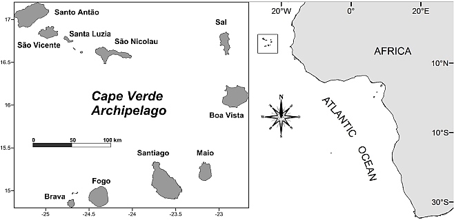
The Cabo Verde Islands are located in
the central eastern Atlantic (14°50’–17°20’N, 22°40’–25°30’W), ca. 750
km west of Senegal. There are 10 islands (of which nine are inhabited)
and eight islets, totalling a land area of 4,033 sq km. The archipelago
was formed by rock accumulation, resulting from eruptions from a
hotspot under submarine platforms. The coastline is 965 km long and the
shelf (depth <200 m) is 5,934 sq km. The largest island, both in
size and population, is Santiago, where the capital of Praia is
located. The climate is arid tropical, with two seasons: a moderate
season (December–June, with an average seawater temperature of
22°–23°C) and a warm season (26°–27°C). Precipitation is meagre and
erratic – indeed Cape Verde can be seen as an island extension of the
arid Sahel zone. The three easternmost islands (Sal, Boavista, Maio)
are relatively flat, highly eroded and have a very arid climate due to
their exposure to dry and hot winds coming from the Sahara. In
contrast, the more western and geologically younger islands (Santiago,
Fogo, Brava, São Nicolau, Santo Antão) have a rugged landscape of high
peaks, ridges, plateaux and deep valleys. Coastlines of the islands are
often cliff-lined or bound by steep slopes that descend to rocky shores
or to beaches of black or white sand.
The four largest islands (Santiago, Santo Antão, Boavista, Fogo) comprise ca. 71% of the total territory, against 28 % for the remaining islands (São Vicente, São Nicolau, Sal, Maio, Brava). The uninhabited island of Santa Luzia and the islets of Raso and Branco (which now have the status of nature reserve protected by law) represent an area of 47 sq km.
The four largest islands (Santiago, Santo Antão, Boavista, Fogo) comprise ca. 71% of the total territory, against 28 % for the remaining islands (São Vicente, São Nicolau, Sal, Maio, Brava). The uninhabited island of Santa Luzia and the islets of Raso and Branco (which now have the status of nature reserve protected by law) represent an area of 47 sq km.


 Santiago
(991 sq km) is the largest island of Cabo Verde, its most important
agricultural centre and home to half the nation’s population. It was
the first of the islands to be inhabited and it is also home to the
nation's capital city of Praia. The island is mountainous, although
slightly flatter in the southeast. The wetter climate of the interior
and the eastern coast contrasts with the dryer one in the south and
southwest.
Santiago
(991 sq km) is the largest island of Cabo Verde, its most important
agricultural centre and home to half the nation’s population. It was
the first of the islands to be inhabited and it is also home to the
nation's capital city of Praia. The island is mountainous, although
slightly flatter in the southeast. The wetter climate of the interior
and the eastern coast contrasts with the dryer one in the south and
southwest.The second largest island is Santo Antão (779 sq km), which is both the most western and most northern islands in the archipelago of Cabo Verde. The island is entirely made up of volcanic material (basalts) and is one of the most mountainous of Cabo Verde. The highest mountain is Topo de Coroa, reaching a height of 1,979 m, the second highest is Pico da Cruz with 1,585 m.
Download a Complete CV Dossier - HERE
caBO verde islands as hot-spot of marine biodiversity
Tuesday, Febuary 21, 2012 11:00 AM Posted by Adm
 Callum M. Roberts, et al. (2002) post Cabo Verde as one of the
eleven coral reef hotspots ranked by degree of threat (ninth position). This important published article is Marine Marine Biodiversity Hotspots and Conservation Priorities for Tropical Reefs: Science 295 (read paper). The measure of biodiversity used to define hotspots is not limited to
rarity, endangered status or endemicity. In regional studies a measure
of species richness may be more common. Approximately 200 sq km in the
mid-Atlantic off the West African coast in Cape Verde the major threats
are coastal development, pollution from land clearing and agriculture,
and over-fishing. more »»»
Callum M. Roberts, et al. (2002) post Cabo Verde as one of the
eleven coral reef hotspots ranked by degree of threat (ninth position). This important published article is Marine Marine Biodiversity Hotspots and Conservation Priorities for Tropical Reefs: Science 295 (read paper). The measure of biodiversity used to define hotspots is not limited to
rarity, endangered status or endemicity. In regional studies a measure
of species richness may be more common. Approximately 200 sq km in the
mid-Atlantic off the West African coast in Cape Verde the major threats
are coastal development, pollution from land clearing and agriculture,
and over-fishing. more »»»